Support Portal
Discover our Support Portal, your one-stop destination for accessing essential resources such as brochures, product datasheets, operation guides, and more.
Explore
Pilot Wireless Network

Small Cell
Drive Test/Outdoor Test

Indoor Test

Autonomous Measurement
Laboratory Automation
Post Processing

Drone-based Testing
Dingli's Pilot Wireless Network Solution is instrumental in ensuring seamless signal transmission between base stations and mobile devices. This cutting-edge solution is tailored to improve the performance, reliability, and efficiency of wireless networks, delivering enhanced network quality and user experience.
Read More Find the related productsSmall Cell Networks power the next wave of wireless innovation, delivering high-quality, reliable connectivity for demanding environments like smart enterprises and hospitals
Read More Find the related productsDrive tests unlock real-world visibility into 4G/5G performance, enabling operators to enhance coverage, signal quality, and user experience.
Read More Find the related productsIndoor Network Test Solutions are essential for evaluating and optimizing cellular networks in indoor environments. Designed to tackle connectivity challenges, they ensure seamless performance in spaces like shopping malls, hospitals, offices, residences, schools, and underground parking lots.
Read More Find the related productsAutonomous Measurement uses advanced tools to monitor and validate network performance, streamlining evaluation and reducing manual effort.
Read More Find the related productsLab test solutions verify 4G/5G performance and reliability before deployment, ensuring every component meets the highest standards
Read More Find the related productsDingli provides cutting-edge Post Processing solutions and a powerful software platform for network analysis and benchmarking, maximizing performance and reliability.
Read More Find the related productsDrone-based network testing enables efficient, flexible, and accurate assessment of wireless performance across low-altitude environments.
Read More Find the related products
Enables seamless smart applications, reliable connectivity, and enhanced driving safety

Cost-effective NB-IoT/Emtc testing solution includes essential measurement functionality, signaling test and enhanced capabilities such as failure alrams and post processing

Measure QoS and QoE for all OTT applications and services

Accelerate digital transformation and improve reliability, efficiency and productivity

Measures and analyzes network performance for low-altitude cellular networks

Verify QoE in 5G networks with a scalable benchmarking solution and ensure the competitiveness of your network

Increase the efficiency of your site verification and accelerate your 5G roll-out

Ensure network quality and end-user satisfaction of wireless networks with professional in-building measurement

Enables mobile voice service provider with a comprehensive, end-to-end solution to ensure better customer experience

Ensure the performance of your 5G network indoors, benchmark your network against competitors

Dingli enhances outdoor network coverage with advanced 4G-5G RAN solutions, bridging the digital gap for urban and rural areas.

Dingli's Private Network Solutions offer secure, customizable, and efficient wireless communication for businesses, enhancing connectivity and operational efficiency.

Dingli's IoT Solutions offer innovative and scalable Internet of Things technologies, enabling smart connectivity and data-driven insights across various industries.

FWA, Fixed Wireless Access, provides high-speed broadband internet via wireless communication, bridging the digital divide in underserved areas.

Dingli excels in Indoor Network solutions, merging 4G reliability with swift 5G speeds for seamless mobile coverage in businesses and public spaces.

Elevator Networks, designed for elevators, uses 5G for high-speed connectivity, real-time monitoring, and seamless communication.

The vast expanse of our oceans, once a communication frontier defined by sporadic signals and limited bandwidth, is rapidly transforming into a thriving digital landscape. As the global marine economy surges and national strategies increasingly focus on maritime development, the demand for robust, reliable, and high-performance wireless networks across sea areas has never been more critical. This is where the expertise of wireless network testing and optimization professionals, armed with the right tools, becomes indispensable.
This article delves into the intricacies of large-scale marine network coverage assessment, drawing insights from a groundbreaking project in Zhejiang Province. We'll explore the unique challenges of offshore network benchmarking, the advanced methodologies employed, and the transformative impact of precise network data, showcasing how cutting-edge tools like Dingli's Pilot Matrix and Pilot Walktour are building confidence and setting new standards for maritime 5G deployment and beyond.
For coastal regions like Zhejiang province, where the marine economy is a cornerstone of growth, stable and pervasive communication at sea is not merely a convenience—it's a strategic necessity. From ensuring the safety of fishermen and facilitating emergency rescues to empowering intelligent fishery management, high-definition shipping backhaul, and digital transformation of island tourism, every facet of maritime activity hinges on reliable connectivity.
However, offshore environments present a formidable array of challenges that are fundamentally different from terrestrial network testing:
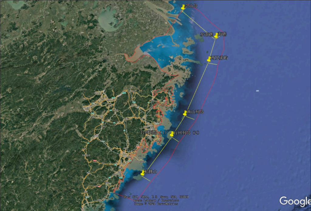
Vast and Dynamic Coverage Areas: Unlike land, the sea offers no fixed infrastructure for signal propagation. Coverage can fluctuate wildly (from 0.21 km near shore to over 43.74 km in far-sea areas), influenced by the curvature of the earth, sea surface reflection, and the sheer distance from coastal base stations. Maintaining consistent signal quality across these distances is a monumental task.
Unique Propagation Characteristics: Saltwater itself can attenuate radio frequency (RF) signals. Multipath fading, caused by reflections off the undulating sea surface or offshore structures like islands, oil rigs, and large vessels, can severely degrade signal quality. Tropospheric ducting, an atmospheric phenomenon, can sometimes extend signals far beyond normal ranges but is unpredictable.
Environmental Volatility: Marine environments are prone to extreme weather conditions—heavy rain, storms, fog, and high winds—all of which significantly interfere with wireless signals and complicate testing logistics. Maintaining stable line-of-sight and signal integrity under such conditions is a constant battle.
Infrastructure Scarcity: The absence of optical cables and the difficulty of deploying and powering offshore base stations mean that reliable infrastructure is sparse, making long-distance communication inherently complex and energy-scarce for remote installations.
Service Delineation: Voice and data services behave differently over the waves due to varying frequency priorities, signal modulation techniques, error correction mechanisms, and network resource allocation. Often, voice services demonstrate better effective coverage than data, and high-frequency 5G bands (like 3.5GHz) experience a sharp drop in speed in far-sea areas, posing a challenge for high-bandwidth applications.
Interference: Beyond natural elements, maritime environments can have sources of interference from other vessel communications (e.g., radar, AIS), satellite communications, and even inter-operator signal bleed, requiring careful identification and mitigation.
These complexities underscore the need for a specialized, rigorous approach to network assessment, going far beyond conventional drive tests.
Recognizing these challenges, the Zhejiang Provincial Sea Area Operator Network Coverage Assessment Project embarked on a mission to systematically evaluate the 4G/5G network quality of China Mobile, China Telecom, and China Unicom across its entire sea domain. The project's core objective was to provide robust data support for marine economic development and maritime communication infrastructure planning.
The project covered approximately 4,500 kilometers of test routes, extending from the coastline's baseline boundary (averaging 46.57 km from shore) to the theoretical coverage limits of each operator's network. This ambitious scope demanded a holistic and highly precise testing methodology.
The success of the Zhejiang project lay in its meticulously designed assessment system, which ensured comprehensive and accurate data collection:
The execution of such a large-scale, complex marine network assessment project was made possible by the intelligent design and robust capabilities of Dingli's professional network testing and optimization tools:

The Zhejiang project was more than just a technical exercise; its findings are directly empowering safety, driving economic growth, and shaping future network investments.
The detailed Voice Call testing and VoNR quality assessment provided critical insights into communication reliability for emergency scenarios. For instance, achieving an impressive voice call success rate exceeding 88% in areas like Zhoushan directly translates to safeguarding the lives of fishermen and shipping personnel. By identifying and addressing areas of poor voice quality or dropped calls, the project has significantly bolstered the lifeline for those at sea.
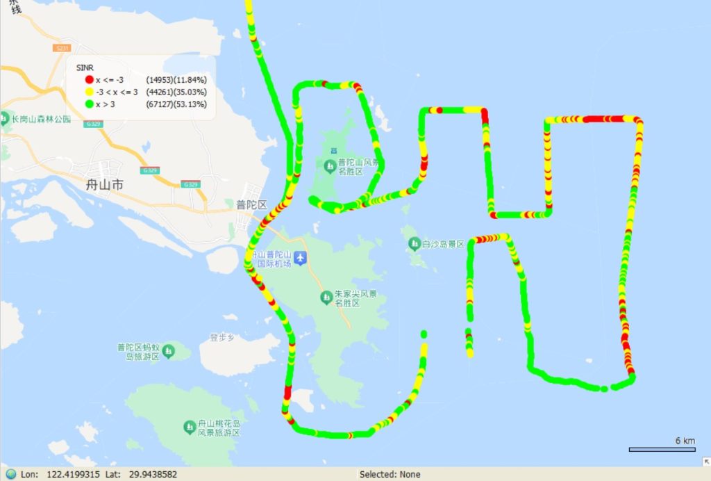
The comprehensive "Sea Area Network Capability Map" generated from the assessment is a game-changer for the marine economy. This map, containing precise heat maps of throughput by operator, signal strength contours, identified dead zones, and areas of high latency, provides invaluable data for:
By exposing coverage deficiencies – for example, finding that over 10% of far-sea 5G downlink speeds were below 5Mbps – the project provided actionable intelligence that has spurred operators to collaborate on base station deployment and technical problem-solving, strategically optimizing their networks to meet the burgeoning demands of the marine sector. The trajectory maps (4G PBM RSRP, 5G PBM SS-RSRP, and SINR) provided to the operators are crucial for their network planning and optimization teams.
The Zhejiang project's innovative methodologies, particularly the "sea baseline extension testing," are now serving as a standardized assessment template for other coastal provinces nationwide. This directly supports China's national "Marine New Infrastructure" and "Maritime Power" strategies, ensuring a consistent and high-quality approach to maritime 5G deployment and network expansion across the country.
The lessons learned, especially regarding the nuanced performance of different frequency bands in marine environments (e.g., the superior penetration of lower frequencies like 700/800/900MHz for voice and emergency communications vs. higher capacity but limited range of 1.8/1.9/2.1/2.6/3.5GHz for data), are critical for strategic network planning. The project also highlighted the significant differences in actual coverage distances among operators due to variations in their base station equipment, locations, antenna heights, and the use of ultra-long-distance technologies. Understanding these disparities through rigorous multiple network benchmarking is vital for informed investment.

The Zhejiang Provincial Sea Area Network Coverage Assessment Project stands as a testament to the power of meticulous wireless network testing and data-driven optimization in challenging environments. It effectively removed the "black box" surrounding sea area network coverage, providing a high-precision, all-service assessment that is directly contributing to enhanced maritime safety and robust marine economic growth.
For wireless network testing and optimization experts in the telecom industry, this case study provides a compelling reference. It demonstrates that with the right approach and advanced tools like Dingli's Pilot Matrix and Pilot Walktour, even the most challenging marine environments can be comprehensively measured, benchmarked, and optimized. These tools empower professionals to:
As the world increasingly looks to the oceans for economic and strategic opportunities, the demand for resilient and high-performance maritime connectivity will only grow. Projects like Zhejiang's, powered by industry-leading solutions from Dingli, are charting a clear course towards a truly "Smart Ocean," equipping telecom professionals with the confidence and precision needed to conquer the waves of wireless network challenges.


If you are interested in our services or need customized solutions, please feel free to contact us
Contact UsComplete the form below to have a sales person address your business needs.

